- Success Stories
- Environmental Resource Assessment & Management
High Resolution Land Cover Maps Now Available
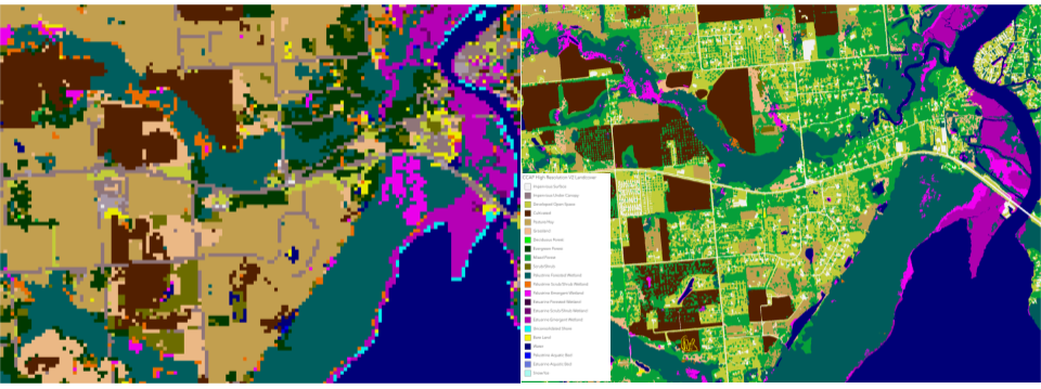
NOAA’s Office for Coastal Management has released higher resolution land cover maps for Alabama, Mississippi, Northeast Ohio, Rhode Island, and the Puget Sound in Washington.
These 1 meter data—previously only available in 30 meter—provide more detail communities need to map and understand their landscapes and features, including tree canopy, wetlands, impervious surface and several other categories. This additional detail will help inform decisions regarding stormwater management, flood mitigation, wetland restoration, and more.
CSS employee owners—subcontracted through Lynker Technologies—contributed to the release of this data set by participating in production activities and providing quality assurance/quality control checks.
Through this effort CSS employee owners help improve community resilience.
Find these new high-resolution land cover data through NOAA’s Digital Coast.
See More CSS Insights
1000 Samples of Lake Water Collected and Processed
Congrats to our team supporting U.S. Environmental Protection Agency’s Office of Research and Development for completing the processing and initial chemical analyses of 1000 lake water samples! They received lake water samples from across the continental U.S. this past summer and have completed the initial chemical analyses as part of the U.S. EPA 2022 National…
Remediating Soil Surrounding Abandoned Mines
CSS employees have been providing field, lab, and horticultural support for the Environmental Protection Agency’s efforts to develop and test methods for the remediation and revegetation of contaminated soils around selected abandoned mines in the western United States. One of the promising approaches is to incorporate biochar into the soil. Using biochar helps effectively adsorb trace metals and reduce their…
Large-Scale Decontamination Proves Successful
In the spring of 2022, we worked with the U.S. Environmental Protection Agency and the U.S. Coast Guard on a project called Analysis for Coastal Operational Resiliency-Wide Area Demonstration (WAD) which tests large scale decontamination following the release of surrogate bioagents. The team conducted a WAD at a military base in Virginia to test decontamination…