
- Employee Spotlight, Success Stories, Uncategorized
- Satellite Science & Environmental Intelligence
CSS Employee Owners Receive NOAA Award

NOAA’s National Environmental Satellite and Data Information Service (NESDIS) recognizes the National Centers for Environmental Information Cloud Archive Team with 2026 NESDIS Outstanding Information Technology and Engineering Team Award! This award recognizes the team’s efforts to develop and deploy the Open Information Stewardship System (OISS) and create a large language model (L-OISS) that automates the generation and testing of complex archive workflows. CSS Employee Owners Elchin Julfayev and Leo Mikula are members of this team and recognized for their contributions.
The innovative and comprehensive approach taken with these current technologies will continue to positively influence future generations, who will benefit immensely from the hard work and perseverance of this team and their larger program.
Congratulations to all on this major accomplishment!
See More CSS Insights
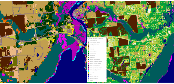
High Resolution Land Cover Maps Now Available
NOAA’s Office for Coastal Management has released higher resolution land cover maps for Alabama, Mississippi, Northeast Ohio, Rhode Island, and the Puget Sound in Washington. These 1 meter data—previously only available in 30 meter—provide more detail communities need to map and understand their landscapes and features, including tree canopy, wetlands, impervious surface and several other categories. This additional detail will help inform decisions regarding stormwater management, flood mitigation, wetland restoration, and more. CSS employee owners—subcontracted through Lynker Technologies—contributed to the release of this…

Fire Detection Support
CSS provides fire detection support to the Atmospheric Science and Technology Applications team with NOAA’s National Environmental Satellite, Data, and Information Services. CSS Surface Characteristics Scientist serves on the Fire Emissions and Fire Detection teams, providing data manipulation, algorithm development, and performance evaluation for the system. This ensures fast and reliable satellite data to stakeholders,…

Developing a Database for Ecosystem Service Models
CSS scientists have been major developers and contributors to the online U.S. Environmental Protection Agency’s EcoService Models Library (ESML) database since its inception in 2012. The ESML database contains detailed but concise descriptions of ecosystem service models to facilitate the selection of models by ecosystem scientists for a variety of management and research applications. The…