- Success Stories
- Satellite Science & Environmental Intelligence
Hurricane Helene One Year Later: Shedding Light on the Impact
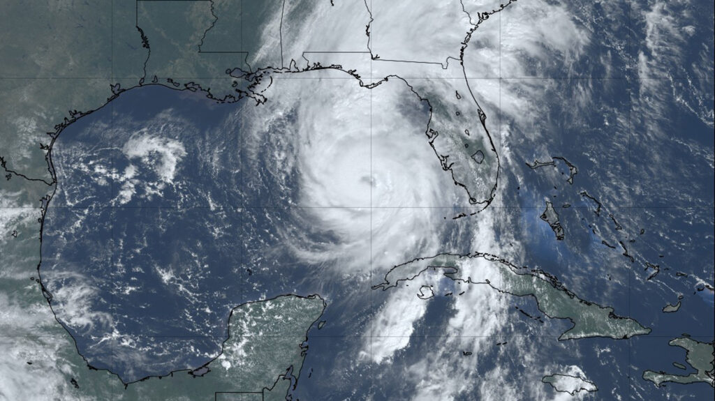
It’s been one year since Hurricane Helene caused catastrophic damage throughout the southern Appalachia region, especially Tennessee and North Carolina, where several rivers experienced above-record flooding. CSS employee owners (previously Riverside Technology, inc.) supporting NOAA’s National Centers for Environmental Information (NCEI) helped develop a Hurricane Helene StoryMap, Helene in Southern Appalachia, a dynamic tool that integrates diverse data sources to provide a comprehensive look at the storm’s impact in some of the worst hit areas.
CSS staff built the technical backbone of the project, laying the foundation through the data processing pipeline and user experience. They developed the core system that pulls data from sources like U.S. Geological Survey (USGS) stations and cities, transforming it into a format that could be displayed in the dynamic dashboard. Throughout this process, the team faced and overcame several technical challenges, including script rewrites and backup solutions for pulling data. They also optimized the dashboard’s performance for both desktop and mobile devices by streamlining data files and exploring different layouts.
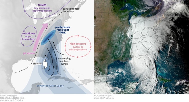
In developing this StoryMap, the team integrated a wide range of external data and applying advanced analytics to enrich the story map’s narrative, including power outage data from the Department of Energy’s EAGLE-I system and night light analyses from NASA’s VIIRS/Black Marble program. In addition, they developed an automated reporting system for flood events using artificial intelligence/machine learning techniques such as k-nearest neighbors (KNN) clustering and density-based spatial clustering of applications with noise (DBSCAN) clustering. These tools were designed to identify rainfall anomalies and group flood zones, streamlining the process of creating flood summaries. This work demonstrated the project’s innovative approach to data analysis and its potential for future applications.
Together, their efforts transformed the Hurricane Helene Story Map into a powerful and informative resource, blending robust technical infrastructure with sophisticated data analysis to tell a complete story of the storm’s impact.
View the recently published StoryMap, Helene in Southern Appalachia, to follow the path of Hurricane Helene, the destruction it caused, and the timeline of recovery.
See More CSS Insights
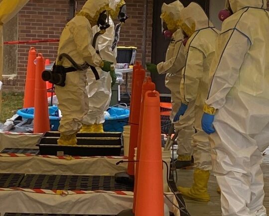
Developing a Decontamination Line Guide for EPA Responders
CSS employee owners supporting the Environmental Protection Agency’s (EPA) Scientific and Technical Assistance for Consequence Management (STACM) contract have been working with the National Chemical Preparedness Workgroup and Sub Workgroups to create a decontamination (decon) line guide and detailed drawing for EPA on-scene coordinators and EPA’s special teams to use for emergency responses and incidents. The…
Atmospheric Processing System Support
The NOAA Unique Combined Atmospheric Processing System (NUCAPS) is an operational retrieval algorithm that NOAA’s National Environmental Satellite, Data, and Information Services has been using since 2002. This system generates near real-time atmospheric profiles of temperature, water vapour, and trace gases, as well as Outgoing Longwave Radiation (OLR) needed for weather forecasting. CSS Remote Sensing…

55 Years of Earth Day!
Since April 22, 1970 — that’s 55 years! — we’ve celebrated Earth Day to raise environmental awareness and support for environmental protection. At CSS we have a passion for the environment and through various government contracts, we work with our clients to overcome challenges to help protect this rock we call home. Below are a…