- Community Spotlight, Success Stories
- Environmental Resource Assessment & Management
Expanding a Popular Flood Exposure Tool
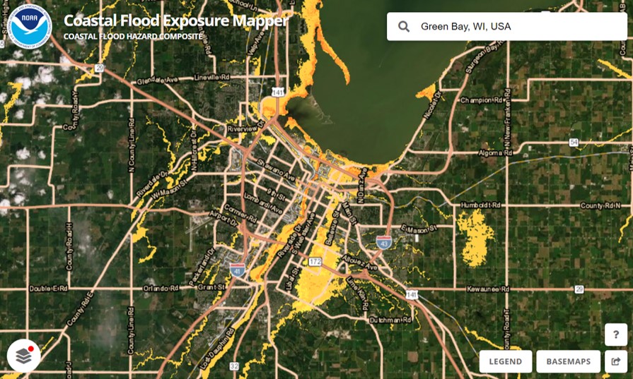
We recently assisted our client, the National Oceanic and Atmospheric Administration’s (NOAA) Office for Coastal Management, with updating one of their most popular tools, the Coastal Flood Exposure Mapper. Our staff provided data management, content development, and outreach support to expand the coverage to the U.S. Great Lakes for some of the flood layers, as well as to include tsunami zones for the East Coast. With this update, users can now view people, places, and natural resources exposed to new flood risks in areas previously not available.
In addition, our communication specialist recommended a higher level of outreach efforts for this expansion to more broadly advertise the implications for the Great Lakes region. This led to engaged interest from NOAA, congressional notifications, a press release, and social media rollouts.
Visit NOAA’s Digital Coast to explore this tool.
See More Success CSS Stories
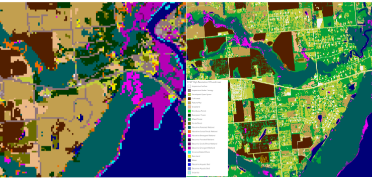
High Resolution Land Cover Maps Now Available
NOAA’s Office for Coastal Management has released higher resolution land cover maps for Alabama, Mississippi, Northeast Ohio, Rhode Island, and the Puget Sound in Washington. These 1 meter data—previously only available in 30 meter—provide more detail communities need to map and understand their landscapes and features, including tree canopy, wetlands, impervious surface and several other categories. This additional detail will help inform decisions regarding stormwater management, flood mitigation, wetland restoration, and more. CSS employee owners—subcontracted through Lynker Technologies—contributed to the release of this…

Assisting Career Growth for Future Coastal Managers
NOAA’s Margaret A. Davidson Fellowship is a two-year fellowship for graduate students that provides an opportunity for them to work side by side with researchers at one of the 30 National Estuarine Research Reserves. The fellowship provides each cohort of fellows with hands-on and cross-disciplinary research experiences, networking opportunities, and professional development and mentoring, helping to prepare them…
Strengthening Risk Communications Training Support to Clients
A CSS employee owner supporting NOAA’s Office for Coastal Management (sub-contracted through Lynker Technologies) has been working closely with colleagues to develop, improve, and deliver trainings related to risk communication. The CSS trainer delivered their first training of Building Risk Communications Skills in Rhode Island to an audience of over 30 coastal managers, planners, practitioners, and a U.S. Representative. The training was well received and will help participants develop new…